I’m going to assume that you haven’t lived under a rock your entire deer hunting life. However, even if you have, I’ll briefly describe what a deer funnel is.
A deer funnel is basically anything that causes deer to pass through a narrow or restricted area. Think of the tiny midsection of an hourglass and you’ll get the picture.
Deer funnels are great places to take your Buck or any other Game animal for that matter.
Deer funnels can be nothing more than how the land lays. Game animals normally follow the lay of the land so anything change in the lay of the land that causes them to pass through a restricted area can be considered a funnel.
Beaver dams can create great deer funnels if the terrain permits. A Beaver dam may be the best crossing over a creek that there is for hundreds of yards. Deer will naturally walk across a Beaver dam before they will swim. So will Hunters!
Man can also create funnels. Fence lines, Ponds, cleared fields, etc. can all create deer funnels.
Below are a few of the popular funnel areas. I’m going to attempt to help you identify deer funnels in your area.
Classic Mountain Saddle Funnel
A saddle in a ridgeline creates the classic funnel. Here is a snapshot of an area I bow hunted quite a bit in the late season. As you can see, it is a perfect funnel. There are two red X’s, each is next to the saddle. When you see deep saddles in ridges like these two, sharpen your hunting knife!
 Both of these spots were a long walk unless you wanted to walk straight up from the road below. I prefer a long fairly straight walk as opposed to a straight up walk!
These saddles produced deer year after year. As you can see, these saddles are on a State PHA. I’ve only seen hunters twice in those saddles in all the years I’ve hunted there. I’m not sure why more people don’t hunt them, but they don’t.
The best bet to hunt funnels like these are in the mornings as the air heats up, the mountain thermals will cause your scent to rise. Deer will normally be coming from the valleys to bed near the top or cross over to the other side.
Deer Funnels In Bottomlands
This next funnel has also been a great funnel area for myself and others.
One funnel is created by a Wet Weather slough pinched up against a river. The red “X” indicates the funnel. This funnel is about 50 yards wide and is great for Bowhunting (as well as Muzzleloader and Gun). There are big open Red Oak flats on each end. During dry times, the slough has thick growth in it. When it rains, it holds water. That’s an old Beaver dam that dissects the slough just above the “X” (our treestand is actually at the end of the Beaver dam you can see in the photo).

The Yellow “X” also represents another funnel. Not quite as effective as the Red “X”, the Yellow “X” has big woods on either end. This about as far away from the Public parking area as you can get. We get into our stand well ahead of daylight and let Hunters push deer to us when we hunt the Yellow “X” funnel.
Man Made Funnels – Fencelines
Ahh fencelines. Not many hunters realize what a great funnel fencelines can make.
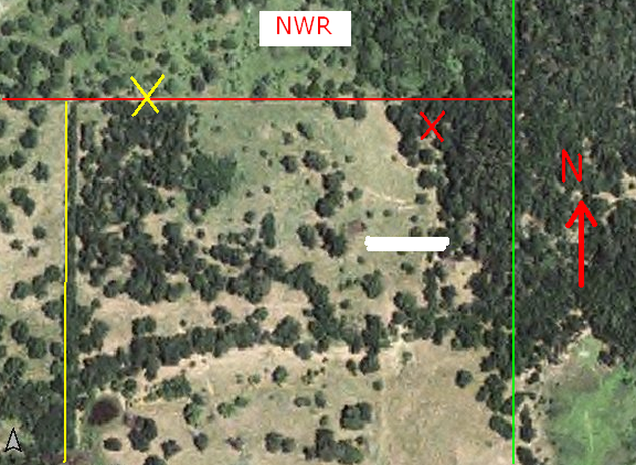
The aerial photo below shows one area I’ve hunted for over a decade.

We hunt the 80 acres in the center. To the West, there is open pasture with a scattering of Pecan and Oak trees. To the North, there is a National Wildlife Refuge with overgrown pastures. To the East and North East, private property and a Agriculture field to the South East.
Deer go back and forth between the West field and the woods on the East side. They also come out of the heavy underbrush on the grown up NWR to the North.
The Red “X” represents one of our stands. We’ve taken 3 – 8 pointers scoring over 130 points out of that stand as the deer follow the fence line.
The Yellow “X” is where an Oak tree fell on the fence about 2 years ago, creating yet another funnel. The NWR fence is a stout fence and it didn’t offer the deer many areas to get across at. When the tree fell, I assume it didn’t take them long to find it as they now have a path beat down across the fence…15 yards from another Red Oak with my stand in it! (on the private land side obviously)
The green line represents another fence running North and South. While not a strong deer magnet, every once in a while a buck will be following it, either going to, or coming from, the Ag field.
You’d think the fence line on the West side, (yellow line, left side) would be a great funnel. But it isn’t. It never has panned out. One reason is that I believe that the fence line is so thick you can not see through it. There are a couple place where coyotes and other critters crawl under the fence, but you’ll be hard-pressed to find any deer sign there. I believe it’s because they can’t see over or through it.
Subtle Deer Funnels
Subtle Deer funnels are areas that you’d normally overlook because you don’t notice the slight change of the terrain. A topo map helps out with this.
This funnel here is a low spot on top of a very wide ridge. So slight we at first overlooked it when we started hunting the property over 20 years ago. If it hadn’t been all the deer tracks in the old road, we’d never set up a stand there.
Luckily we did because this was a “Guaranteed” stand if there ever was one. I can’t remember how many deer we killed out of that stand, but it was many. About 8 years ago the landowner sold the land and that ended our hunting on the property.
 Notice how there is a slight rise on each side of the X? Basically this is a saddle, but you’d probably not recognize it if you drove down the road.
Deer would come from the right, cross through the saddle and down the point of the ridge and into the fields below.
In the Mornings, they be coming back from the fields.
During the rut, or when a front approached, it was an all day stand because you never knew when deer would show up!
So break out your topo maps and aerial photo’s and find those Funnels! Just remember not all funnels are created equal, some good looking funnels are never used by deer for one reason or another. While subtle funnels like the one above can produce deer year after year.
Places To Find Aerial Photo’s Online
Check with your state’s game dept. Many states are now putting up aerial photo’s and topo grids for popular WMA’s.
A great resource for Aerial photo’s is the Microsft’s TerraServer. It’s free and covers many areas of the U.S. On many of these maps, you can switch from Aerial Photo to Topo Grid. This makes it sweet!
I’m told that Google Earth has some fine Aerial Photo’s and not of people on the Beach! I’ve never tried it though. Here’s the link if you’d like to try Google Earth.
Take the time to search out funnels in your hunting area. I’ve never seen a hunting area that didn’t have them!alloutprodux.com


